
Peer Through a Modern Lens Into 1880s LA (or Vice Versa)
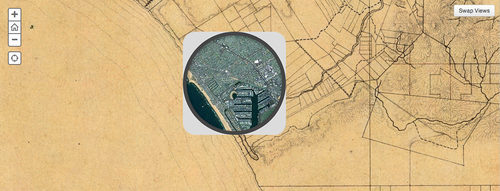
Aside from a real lack of development, 1880ish Los Angeles was strikingly similar to the one we know today, as we can see from this great map thingy from the Smithsonian. They’ve layered a modern-day satellite image of the city with an unfinished map made by the very first California state engineer sometime around 1880, according to map-spert David Rumsey (the one-of-a-kind map comes from his collection). Swap views to see the old or new map on top while the other shows through an oculus. In the late nineteenth century, State Engineer William Hammond Hall led a team “in charge of trying to figure out all of the water resources of L.A. and how to use the water that was there. You’ll notice the map has a great emphasis on drainage – it shows all the hills very clearly and all the canyons. They were very interested in water.” Obviously plenty’s changed since the survey, but it’s also remarkable to see the similarities–roads and railways that run along the paths of current boulevards and freeways, bodies of water on the site of manmade features like the marina and the port, and the general course of the LA River (on the “differences” front, you can also see how it’s been reined in).
Check out more on this topic
